Americans type their ZIP Codes into everything from mailing labels to online orders, but those five familiar numbers contain a geographic system designed more than six decades ago to help move mail across the country.
UNITED STATES — August 31, 2026 — You probably know your ZIP Code without thinking about it.
Five numbers get added to the end of your address when you order a package, fill out a form, apply for something online or send a letter.
But why those particular numbers?
And what does your ZIP Code actually mean?
The answer dates back more than six decades, when America’s growing population and enormous volume of mail created a logistical problem for the nation’s postal system.
The solution was a five-digit code that could essentially tell the postal system where a piece of mail needed to travel.
Those numbers weren’t randomly assigned.
They represent a geographic hierarchy that moves from a broad region of the United States toward a much more specific destination.
ZIP Actually Stands for Something
ZIP stands for Zoning Improvement Plan.
The U.S. Post Office Department, the predecessor of today’s United States Postal Service, introduced the five-digit ZIP Code on July 1, 1963.
The goal was straightforward: make processing and delivering America’s growing volume of mail faster and more efficient.
Before ZIP Codes, postal employees relied heavily on their knowledge of geography and thousands of post offices around the country when sorting mail.
The new numerical system consolidated much of that geographic information into five digits that could be read quickly by workers and, increasingly, mail-processing equipment.
It also helped prepare America’s postal network for greater mechanization and eventually automation.
More than 60 years later, the basic five-digit system remains part of virtually every American address.
The First Digit Tells You What Part of America You’re In
Take a five-digit ZIP Code and look at the first number.
That digit represents a broad geographic region of the United States.
The system generally starts in the Northeast with 0 and moves westward across the country until reaching 9 in the western United States.
That means ZIP Codes beginning with lower numbers tend to be found in the eastern part of the country, while those beginning with higher numbers generally belong to western states.
For example, ZIP Codes beginning with 0 are found in parts of the Northeast.
Move across the country and the first digit gradually increases.
California ZIP Codes generally begin with 9.
The system effectively gave the postal network a numerical map of the United States.
Before anyone even reads the remaining four digits, that first number has already narrowed the destination to a major portion of the country.
The Next Two Digits Narrow the Destination
Now look at the first three digits together.
The second and third digits further narrow the geographic destination.
Historically, these numbers directed mail toward regional processing areas known as sectional centers.
Instead of every postal employee needing to determine exactly where every town in America was located, the first three digits could help move mail toward the appropriate regional destination.
Imagine the ZIP Code as a funnel.
The first digit identifies a broad part of the United States.
The next two digits narrow that down to a more specific regional area.
Then the final two digits take the mail another step closer to where it needs to go.
The Last Two Digits Get Much More Specific
The fourth and fifth digits historically identify a specific post office or postal zone within the larger regional area.
Put all five together and the postal system has a compact set of geographic instructions.
In simplified form:
First digit → broad U.S. region
Next two digits → regional sorting area
Last two digits → specific post office or postal zone
It is essentially a five-number navigation system for mail.
That may seem simple today, when computers can instantly recognize an address, but in 1963 it represented a major change in how America’s mail moved.
Why America Needed ZIP Codes
The ZIP Code was not invented simply to make addresses look more organized.
America’s postal network was dealing with enormous growth.
According to the Smithsonian’s National Postal Museum, mail volume had doubled after World War II, putting increasing pressure on the postal system.
Sorting mail also required extensive geographic knowledge.
Postal clerks needed to know the names and locations of thousands of post offices so letters and packages could be routed toward the correct destinations.
As mechanized mail processing expanded, numbers offered something machines could work with much more efficiently.
A ZIP Code translated a complicated destination into standardized information.
Large-volume mailers could also presort their mail according to postal regions before handing it over to the postal system, reducing some of the sorting that would otherwise need to happen later.
ZIP Codes therefore weren’t merely about identifying where Americans lived.
They were part of a larger transformation toward mechanized and eventually automated mail processing.
Americans Didn’t Immediately Love the Idea
Today, adding a ZIP Code to an address seems completely normal.
Americans in the early 1960s didn’t necessarily see it that way.
The government was essentially asking the entire country to memorize additional numbers and start including them whenever they addressed mail.
The Post Office Department launched a nationwide publicity campaign to convince people to adopt the new system.
One of its biggest weapons was a cartoon character.
His name was Mr. ZIP.
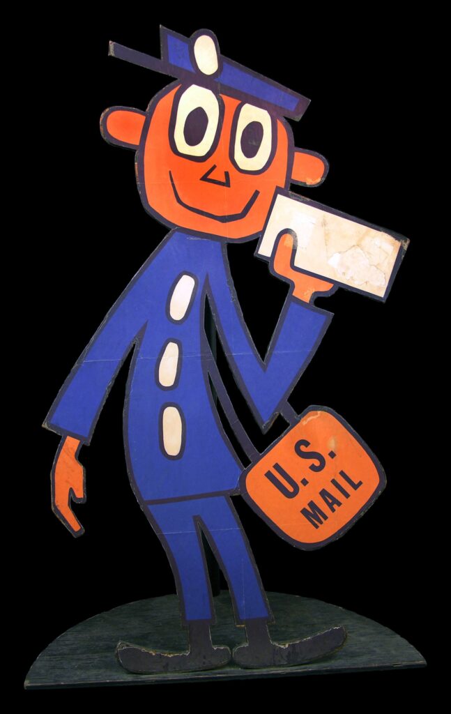
The smiling postal character appeared in advertisements and public service announcements reminding Americans to use their new five-digit codes.
Mr. ZIP became extraordinarily recognizable.
According to the U.S. Postal Service, within four years of his appearance, eight out of 10 Americans knew who Mr. ZIP was and what he represented.
The campaign worked.
ZIP Codes eventually became so commonplace that most Americans today probably couldn’t imagine writing their address without one.
Then Came ZIP+4
Five digits dramatically improved mail sorting, but the postal system eventually wanted even greater precision.
In 1983, the Postal Service introduced ZIP+4.
You’ve probably seen one even if you don’t regularly use it.
Instead of:
12345
the address might look something like:
12345-6789
Those additional four digits allow the postal system to narrow the destination beyond the basic five-digit ZIP Code.
They can identify a particular delivery section, such as a group of streets, city blocks, post office boxes or a large building.
In other words, the original five digits get the mail into a relatively specific geographic area.
ZIP+4 gets even closer to the final destination.
Modern postal technology can become more precise still as mail moves through automated processing and toward an individual residence or business.
There Are More Than 41,000 ZIP Codes
The United States currently has more than 41,000 ZIP Codes, according to USPS.
And they include some interesting extremes.
One of the lowest ZIP Codes is 00501, associated with the Internal Revenue Service in Holtsville, New York.
At the opposite end is 99950 in Ketchikan, Alaska.
There is even a ZIP Code that’s unusually easy to remember:
12345.
That ZIP Code is associated with General Electric in Schenectady, New York.
Some organizations receive enough mail that they can have their own unique ZIP Code.
Meanwhile, the geographic size represented by a ZIP Code can vary enormously.
In a densely populated city, a ZIP Code may cover a relatively compact area containing thousands of addresses.
In sparsely populated parts of the country, one ZIP Code can stretch across thousands of square miles.
The ZIP Code 89049, serving the Tonopah area of Nevada, covers more than 10,000 square miles and is the largest ZIP Code in the contiguous United States, according to USPS.
A ZIP Code Isn’t Exactly the Same Thing as a Neighborhood
This is where ZIP Codes become particularly interesting.
People often use them as geographic identities.
Someone might describe a neighborhood by its ZIP Code. Businesses use ZIP Codes to define service areas. Websites use them to find nearby stores. Researchers and marketers use them to examine communities.
But ZIP Codes weren’t originally created to define neighborhoods.
They were created to deliver mail.
That distinction matters.
A ZIP Code can cross boundaries people otherwise think of as separating communities, and the geographic area associated with a ZIP Code doesn’t necessarily correspond perfectly with a city, neighborhood or other governmental boundary.
Its primary purpose is postal routing.
Over time, however, those five numbers became useful for far more than envelopes.
ZIP Codes Escaped the Mailbox
Think about how often you’re asked for your ZIP Code even when nobody is mailing you anything.
Retailers ask for it.
Websites use it to locate nearby stores.
Insurance companies use geographic information when determining rates.
Businesses use ZIP-related data to understand customers and markets.
Researchers use ZIP-based geography to study populations.
Emergency-response systems also rely on address and location information.
A numerical system invented to help postal employees sort America’s growing mountain of mail has become one of the country’s most recognizable ways of organizing geographic information.
And the postal system itself continues growing.
USPS says it now serves more than 170 million addresses across the United States and adds thousands of addresses to its delivery network on an average day.