On May 18, 1980, residents of the Pacific Northwest witnessed one of the deadliest and most destructive volcanic eruptions in United States history.
A magnitude 5.1 earthquake struck at 8:32 a.m., triggering the collapse of the volcano’s north flank and a massive landslide and lateral blast that raced across the landscape at hundreds of miles per hour. 57 people died, entire forests were destroyed, and ash from the volcano spread throughout many states.
More than four decades later, the eruption remains an important reference point in both Pacific Northwest history and volcanology. The Mount St. Helens eruption transformed volcano monitoring, hazard assessment, risk communication, and the study of ecological recovery after natural disasters.
What began as devastation ultimately became one of the most important scientific laboratories on Earth.
The Warning Signs Before the Eruption
Before 1980, Mount St. Helens was often described as the “Fujiyama of America” because of its symmetrical beauty. Although geologists understood that Mount St. Helens remained an active volcano capable of erupting again, many residents underestimated the threat.
Before the eruption, scientists documented numerous warning signs of volcanic activity at Mount St. Helens, including earthquakes, steam venting, and growing deformation along the volcano’s north flank.
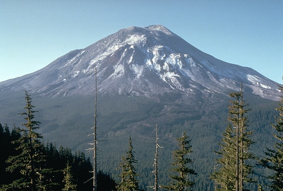
Harry Glicken, USGS/CVO / Wikimedia Commons (Public Domain)
https://commons.wikimedia.org/wiki/File:Mount_St._Helens,_one_day_before_the_devastating_eruption.jpg
https://www.usgs.gov/information-policies-and-instructions/copyrights-and-credits
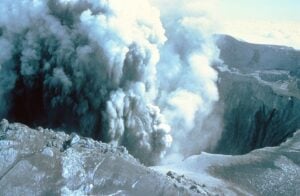
The Catastrophic Eruption of May 18, 1980
Scientists from the U.S. Geological Survey monitored the activity closely, but modern volcano monitoring technology was still in its infancy. By 1980, Mount St. Helens had limited on-site seismic monitoring equipment, restricting scientists’ ability to fully interpret activity beneath the volcano.
When the eruption finally occurred, it exceeded many expectations. The volcano’s north flank collapsed in what is widely considered the largest landslide in recorded history. The lateral eruption devastated approximately 230 square miles (600 square km) of forest and destroyed neighborhoods and infrastructure with pyroclastic flows, mudflows, and ash clouds. Total damage was estimated at over $1 billion.
The eruption also killed volcanologist David A. Johnston, who was stationed at an observation post near Mount St. Helens. Johnston’s last radio transmission — “Vancouver, Vancouver, this is it!” — became one of the most memorable moments of the disaster. Johnston’s death exemplified the dangers faced by volcanologists and highlighted the need for improved volcanic hazard forecasting.
How Mount St. Helens Changed Volcanology
The eruption became a major turning point for earth science research.
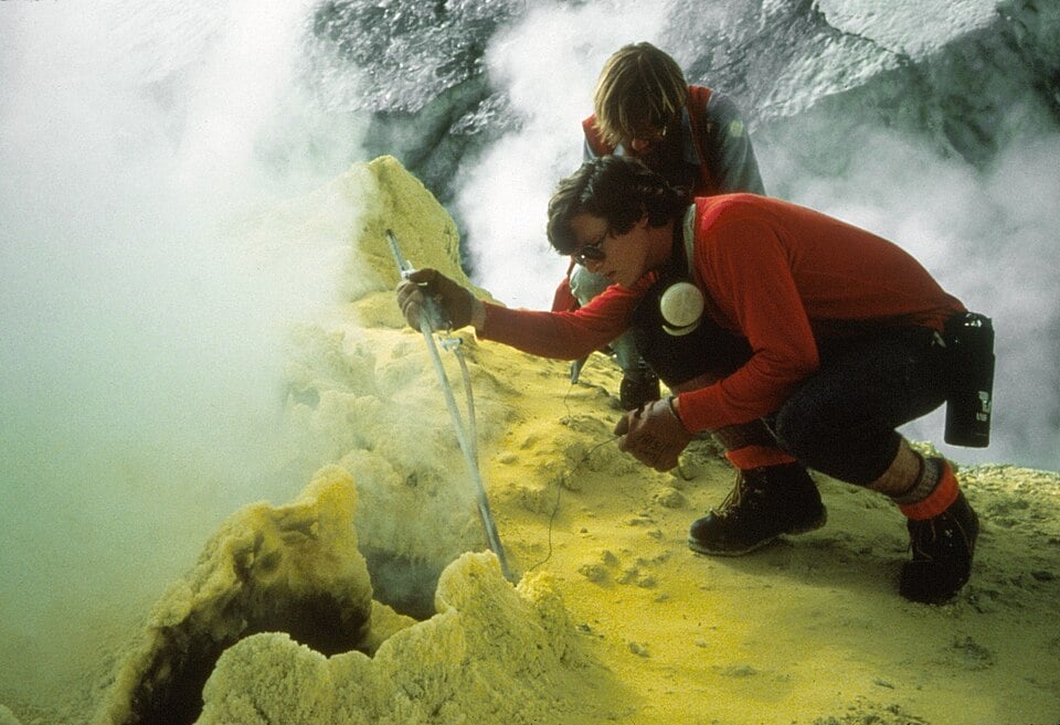
Photo by W. Chadwick / U.S. Geological Survey (USGS), via Wikimedia Commons. Public Domain (U.S. Government work – USGS)
Baker Fumarole image page
USGS copyright and public domain policy
The Mount St. Helens eruption gave scientists a rare opportunity to study a major volcanic eruption up close. According to the USGS, the eruption was the first large explosive volcanic event observed using many modern volcanology techniques. The mountain’s accessibility and extensive photographic documentation provided researchers with enormous amounts of data.
In the years that followed, the eruption fundamentally changed volcano monitoring around the world.
“That was really a turning point. From a tragedy, you learn a lot—which can help mitigate problems down the road,” volcanologist Don Swanson said, according to an article in Washington State Magazine, while reflecting on how Mount St. Helens reshaped scientific understanding of volcanic hazards.
Advances in Volcano Monitoring and Hazard Preparedness
One of the most important developments was the expansion of seismic monitoring networks. Researchers found that earthquake activity beneath volcanoes often provides early warning signs of eruptions. As the USGS later explained, “The May 18, 1980 eruption of Mount St. Helens triggered a growth in volcano science and volcano monitoring.”
Mount St. Helens is currently monitored using many sophisticated instruments capable of detecting small earthquakes, gas emissions, and subtle ground deformation. GPS systems can detect minute changes in the shape of the volcano, allowing scientists to monitor magma movement underground well before an eruption.
The eruption also led directly to the creation of the USGS Cascades Volcano Observatory in Vancouver, Washington. Ultimately, the goal of developing an observatory was to enhance both hazard monitoring and preparedness for all of the Cascades; in particular, those volcanoes within the Cascade Range that pose significant volcanic hazards, such as Mount Rainier, Mount Hood, and Lassen Peak.
Scientists now use a wide range of tools to study volcanic activity, including satellite imagery, seismology, gas monitoring, drones, and computer modeling. Many of these advances were influenced by lessons learned from the 1980 eruption. New, modern monitoring techniques have enabled scientists to both provide earlier warning and also to formulate better evacuation plans for residents living near volcanically hazardous areas; helping communities prepare for future eruptions and reducing loss of life.
The Eruption That Changed Disaster Preparedness
The disaster also changed how emergency management officials communicate risk to the public. Prior to 1980, many residents underestimated the danger posed by volcanoes in the continental United States.
U.S. Forest Service – Pacific Northwest Region / Public Domain via Wikimedia Commons
Wikimedia Commons Image Page
Public Domain License Information
Some residents ignored evacuation zones established around Mount St. Helens despite warnings from officials. The experience showed that having clear hazard maps, providing public education, and establishing emergency response plans work well to aid in the coordination of appropriate responses.
Scientists today continue preparing for future eruptions in the Pacific Northwest. According to the USGS Cascades Volcano Observatory, Mount St. Helens remains the most active volcano in the Cascade Range and is likely to erupt again someday. However, experts say modern technology makes it far more likely that communities would receive advance warning.
Ecological Recovery After the Blast
Beyond volcanology, Mount St. Helens also revolutionized ecological science.
According to the USDA, “Today, Mount St. Helens is the most studied volcano in the world and has changed how we understand ecological recovery.”
Nature’s Unexpected Resilience
Immediately after the eruption, many experts believed the blast zone would remain barren for decades. Forests had been flattened, lakes filled with ash and debris, and much of the surrounding terrain appeared lifeless. Yet nature recovered in ways scientists did not expect.
Researchers soon discovered that pockets of life had survived beneath snow, underground, and in protected areas. Plants, insects, amphibians, and small mammals slowly returned. Scientists studying the recovery process found that ecosystems are often far more resilient than previously believed.
According to an article in Business Insider, researchers later observed, “They had expected to find nothing. Instead, there were still carpenter ants, frogs, pocket gophers, spiders, and other signs of life.”
Dirtsc / CC BY-SA 4.0 via Wikimedia Commons
Wikimedia Commons Image Page
Creative Commons Attribution-ShareAlike 4.0 License
The Volcano as a Living Laboratory
One of the most famous recovery experiments involved northern pocket gophers. Scientists introduced the animals into portions of the devastated landscape in the early 1980s. As the gophers burrowed through the ash-covered soil, they helped aerate the ground and spread beneficial fungi and microorganisms, accelerating plant growth.
As time progressed following the eruption of Mt. St. Helens, some regions that had been almost devoid of any living plant material were recolonized by plants. This recovery gave scientists an opportunity to study how ecosystems rebound after catastrophic disturbances.
Decades of research on forests, aquatic systems, wildlife behavior, and ecological resilience have made Mount St. Helens one of the world’s leading natural laboratories for ecology and biology.
Researchers found that recovery rates varied depending on the severity of the eruption and whether seeds, roots, or organisms survived beneath the surface. Areas that experienced less intense damage often recovered more quickly than heavily scorched regions.
Mount St. Helens’ Lasting Global Impact
The consequences of the eruption went beyond just the Pacific Northwest. Scientists studying volcanoes all over the planet have applied what they learned from Mount St. Helens to enhance their ability to evaluate hazardous volcanoes all over the planet. There was a significant impact on monitoring techniques of volcanoes located in Alaska, Hawaii, Indonesia, the Philippines, etc. Hazard maps, evacuation planning, and interdisciplinary volcano research all advanced significantly in the decades after 1980.
The eruption also inspired a new generation of scientists. Programs connected to Mount St. Helens continue educating students about geology, ecology, and hazard preparedness.
A Volcano Still Being Watched Today
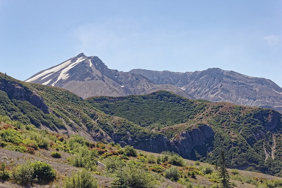
Even today, the mountain continues changing.
Steam still rises from parts of the crater, occasional seismic activity continues, and scientists closely monitor Mount St. Helens. Small earthquakes and increased seismic activity continue at Mount St. Helens, though experts say there are no signs of an imminent eruption.
The crater also illustrates nature’s power to both destroy and renew.
Forests have regrown across much of the blast zone, wildlife has returned, and visitors now travel there to witness one of modern history’s most remarkable natural recoveries.
Legacy of the Mount St. Helens Eruption
The Mount St. Helens eruption transformed volcanology and greatly improved understanding of volcanic hazards over the past 46 years. Volcanologists now use the latest technology to monitor volcanoes. The Mount St. Helens eruption also improved preparedness for volcanic hazards in high-risk areas.
Most importantly, Mount St. Helens showed that even after enormous destruction, recovery — both environmental and scientific — is possible. The experience of studying volcanoes has progressed due to the lessons learned from volcanic eruptions such as those of 1980. Future generations will be better prepared when the next eruption occurs because of these lessons.
Sources:
U.S. Geological Survey — “Overview of the Mount St. Helens volcanic eruption”
U.S. Geological Survey — “Prepare for the Next Volcanic Eruption in the Pacific Northwest”
Washington State Magazine — “Mount St. Helens: The aftermath and lessons learned”
U.S. Geological Survey — “1980 Cataclysmic Eruption”
U.S. Geological Survey — “Ways the 1980 Mount St. Helens Eruption Changed Our World”
U.S. Department of Agriculture — “Past, Present, and Future Research on Mount St. Helens”
U.S. Geological Survey — “Ecology of Mount St. Helens National Monument”
Editor’s Disclaimer: This article is intended for educational and historical informational purposes. While every effort has been made to ensure accuracy, scientific understanding and monitoring data regarding volcanic activity may evolve over time. Readers are encouraged to consult official sources such as the U.S. Geological Survey (USGS) and the Cascades Volcano Observatory for the latest scientific updates and hazard information regarding Mount St. Helens and other active volcanoes.